Training Course on GIS Mapping and Spatial Analysis for Monitoring and Evaluation
Training Course on GIS and Remote Sensing for Sustainable Agriculture
Training Course on Advanced Geospatial Technologies & Enterprise GIS for Urban and Environmental Applications

Module 1: Foundations of Enterprise GIS and Spatial Data Infrastructures

Module 2: Advanced Geodatabase Design and Management

Module 3: Spatial Data Interoperability and ETL Workflows

Module 4: Advanced Spatial Analysis and Geoprocessing

Module 5: Remote Sensing for Urban and Environmental Monitoring

Module 6: LiDAR Data Processing and Advanced 3D Modeling

Module 7: Web GIS Architecture and Development

Module 8: Server-Side GIS with ArcGIS Enterprise/GeoServer

Module 9: Front-end Web Mapping with JavaScript APIs

Module 10: Big Data Analytics for Spatial Data

Module 11: Artificial Intelligence and Machine Learning in Geospatial Applications

Module 12: Network Analysis and Optimization for Urban Systems

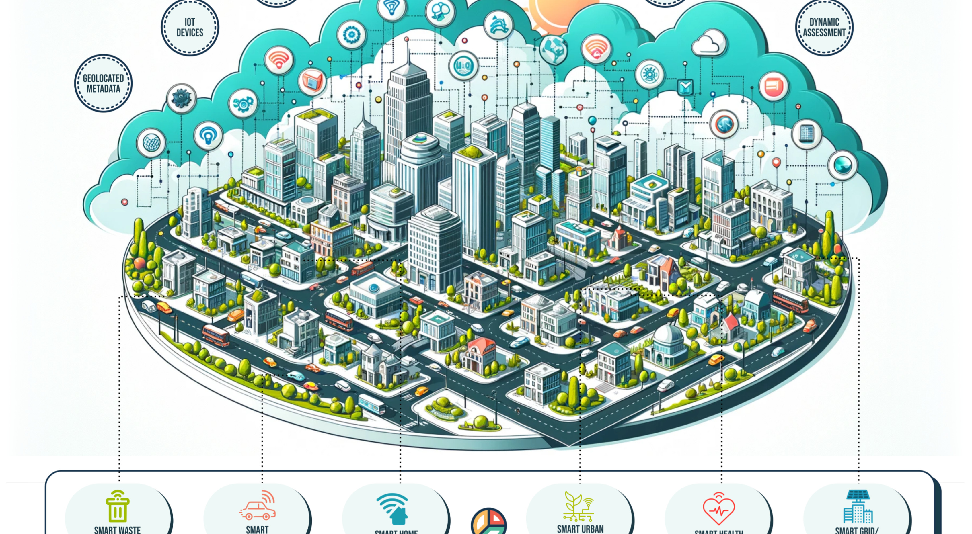
Module 13: GIS for Smart Cities and Urban Planning

Module 14: Environmental Modeling and Impact Assessment with GIS

Module 15: GIS for Disaster Management and Humanitarian Response

Module 16: Mobile GIS and Field Data Collection Solutions

Module 17: Data Quality, Metadata, and Governance in Enterprise GIS

Module 18: Project Management and Implementation of Enterprise GIS

View Course Details
Training Course on Advanced Geospatial Technologies for Urban and Environmental Applications

Module 1: Advanced Spatial Econometrics for Urban and Regional Economists

Module 2: LiDAR Data Processing and 3D Modeling for Surveying Engineers

Module 3: Hyperspectral Remote Sensing Applications for Geologists and Mineral Explorationists

Module 4: GIS for Public Health Surveillance and Epidemiology for Health Analysts

Module 5: Satellite Image Analysis for Deforestation Monitoring for Conservation Scientists

Module 6: Web GIS Development and Application Deployment for Geospatial Developers

Module 7: Drone (UAV) Photogrammetry and Mapping for Precision Agriculture Specialists

Module 8: Spatial Database Management and Enterprise GIS for GIS Administrators

Module 9: Network Analysis for Logistics and Transportation Planners

Module 10: Remote Sensing of Water Resources for Hydrologists

View Course Details
Training Course on Advanced Spatial Econometrics for Urban and Regional Economists

Module 1: Introduction to Spatial Econometrics and Spatial Data

Module 2: Detecting and Modeling Spatial Autocorrelation

Module 3: Spatial Lag Models (SAR) and Their Estimation

Module 4: Spatial Error Models (SEM) and Their Estimation

Module 5: Spatial Durbin Models (SDM) and Direct/Indirect Effects

Module 6: Advanced Topics in Spatial Regression and Estimation

Module 7: Spatial Panel Data Models

Module 8: Discrete Choice and Count Data Spatial Models

Module 9: Model Selection and Diagnostic Testing in Spatial Econometrics

Module 10: Applications of Spatial Econometrics in Urban and Regional Studies

View Course Details
Training Course on Applied Geospatial Technologies for Public Health, Conservation, and Web Development

Module 1: Introduction to GIS and Spatial Data for Applied Fields

Module 2: GIS for Public Health: Data Management and Mapping

Module 3: Spatial Epidemiology and Disease Surveillance Techniques

Module 4: Fundamentals of Remote Sensing for Environmental Monitoring

Module 5: Satellite Image Analysis for Deforestation and Forest Change

Module 6: Advanced Change Detection and Forest Dynamics Monitoring

Module 7: Introduction to Web GIS and Web Mapping Concepts

Module 8: Client-Side Web GIS Development with JavaScript Libraries

Module 9: Server-Side Web GIS and Data Publishing

Module 10: Deploying and Managing Web GIS Applications

View Course Details
Training Course on Satellite Image Analysis for Deforestation Monitoring for Conservation Scientists

Module 1: Fundamentals of Satellite Remote Sensing for Forests

Module 2: Satellite Image Acquisition and Pre-processing

Module 3: Spectral Indices and Forest Health Assessment

Module 4: Image Classification for Forest Cover Mapping

Module 5: Introduction to Change Detection for Deforestation

Module 6: Advanced Change Detection Techniques

Module 7: Quantifying Deforestation and Accuracy Assessment

Module 8: Time Series Analysis for Forest Dynamics

Module 9: Drivers of Deforestation and Policy Implications

Module 10: Reporting and Visualizing Deforestation Monitoring Results

View Course Details
GIS Mapping and Web Development Training Course

Module 1: GIS Fundamentals and Data Basics

Module 2: Spatial Data Creation and Management

Module 3: Introduction to Web Development

Module 4: The Building Blocks of Web Maps

Module 5: Advanced Web Mapping Techniques

Module 6: Working with Geospatial APIs

Module 7: Integrating GIS with Databases

Module 8: Server-Side Web Mapping

Module 9: Designing User Interfaces for Maps

Module 10: Final Project: Building a Complete Web Mapping Application

View Course Details
Masterclass in Web GIS for Urban Planners and Environmental Scientists

Module 1: Fundamentals of Web GIS

Module 2: Web Mapping with Leaflet

Module 4: Web Mapping with OpenLayers

Module 5: Building a Full-Stack Web GIS Application (Part 1)

Module 6: Building a Full-Stack Web GIS Application (Part 2)

Module 7: Advanced Data Visualization and Styling

Module 8: Integrating Geospatial APIs

Module 9: Mobile and Responsive Web Mapping

Module 10: Deploying and Maintaining Your Web GIS Application

View Course Details
Spatial Analysis and Visualization with Advanced QGIS Training Course

Module 1: Advanced Geoprocessing and Vector Analysis

Module 2: Introduction to Raster Data Analysis

Module 3: Advanced Raster Techniques and DEM Analysis

Module 4: Spatial Statistics and Geostatistics

Module 5: Database Integration with PostGIS

Module 6: Automating Workflows with the Graphical Modeler

Module 7: Introduction to PyQGIS (Python Scripting)

Module 8: Creating Professional Map Layouts

Module 9: Data Management and Quality Assurance

Module 10: Capstone Project: A Comprehensive Spatial Analysis

View Course Details
Advanced Geospatial Analytics and Leadership Certification Course

Module 1: GIS Fundamentals and Introduction to Geostatistics

Module 2: Geospatial Data Acquisition and Management

Module 3: Advanced GIS Mapping and Analysis Techniques

Module 4: Geospatial Big Data Analytics

Module 5: Web GIS Development and Applications

Module 6: Python Programming for GIS Application Development

Module 7: Web GIS Mapping Training and Deployment

Module 8: The Geospatial Leadership Training Program

Module 9: Spatial Statistics and Geostatistics

Module 10: Case Studies and Capstone Project

View Course Details
Training Course on Satellite Imagery Analysis for Geospatial Professionals

Module 1: Fundamentals of Remote Sensing and Satellite Imagery

Module 2: Satellite Image Processing and Enhancement

Module 3: Image Classification and Feature Extraction

Module 4: Change Detection and Time-Series Analysis

Module 5: Applications in Environmental Monitoring and Management

Module 6: Applications in Urban Planning and Development

Module 7: Introduction to Radar and Other Non-Optical Imagery

Module 8: GIS Integration and Data Management

Module 9: Advanced Techniques and Machine Learning in Analysis

Module 10: Case Studies and Project Implementation

View Course Details
Please wait...
Phoenix Training Center

Phoenix Training Center
Typically replies in minutes

Phoenix Training Center
Hi there 👋

We are online on WhatsApp to answer your questions.
Ask us anything!
×
Chat with Us